The Storm

Only FOUR MORE DAYS until Shep is unleashed!
Today’s blog is about the storm itself. And what a storm it is! Once I knew that I needed a storm to destroy my city and that my story was set in Miami, I knew I had to design a massive hurricane. But what constituted a massive hurricane? And how do hurricanes work, anyway?
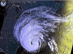
I started with the basics. A hurricane is a super strong storm system characterized by high winds, violent thunder and lightning, and torrential rain. Another name for a hurricane is a tropical cyclone: the “tropical” referring to the fact that the storms form over warm ocean water in the tropics and the “cyclone” referring to the spinning nature of the winds—hurricanes normally look like a swirl of white cloud around a circular, cloud-free “eye” of the storm. They pose a great danger to coastal regions because they maintain their strength by drawing moisture from warm water. Once a hurricane crosses onto land, it loses its strength.
When I say high winds, I mean high winds! The lowest category of hurricane—a category 1—has sustained winds of more than 74 miles-per-hour, and a category 5 hurricane—the highest category—has sustained winds of more than 157 miles-per-hour. As if the gusting winds and pouring rain of a hurricane aren’t damaging enough, the cyclonic nature of the storm can result in tornadoes. Also, the hurricane’s strong winds can cause storm surges, resulting in devastating floods.
These are pictures taken after the 1926 hurricane that hit Miami.


Notice the boats in the middle of the street!
Here’s a map showing the paths of all major hurricanes in North America from the late 19th century to the present. Notice how many of them cross southern Florida…

I show this because I used storms that actually happened to help design my “perfect storm.” Specifically, the storm that attacks Miami in The Storm is meant to be a combination of Hurricanes Andrew and Wilma, actual storms that tore through Florida in 1992 and 2005.
My storm begins as a Wilma-like storm crossing over Florida from west to east.

By the time is reaches Miami, it has been weakened from crossing over land. But instead of passing over Miami and heading north into the Atlantic Ocean like Wilma did, my storm stalls over Miami because of the approach of a second storm—an Andrew-like storm driving west toward Florida across the Atlantic.

As the first storm stalls over Miami, it pulls in moisture from the ocean and regains some of its strength. Then the Andrew-like storm approaches landfall in Miami and forces a huge storm surge of water over the land. Finally, the two storms combine into a SUPER STORM!
As I revised The Storm, I created an hour-by-hour chart to keep track of my storms’ progress with respect to the plot. Watch for the different phases of the storm in the story—its arrival, the crossing of the calm “eye” of the storm… I hope you enjoy all the havoc I wreak!
Tomorrow’s blog is on all the research I did to create an authentic “dog’s eye view” of the world. And then on Friday I’ll announce a contest for your chance to win signed copies of the first two books in the series and a series bookmark!

